| name | elevators | floors below ground | image | status | style | Area (m²) | type | use | date completed | Cost | Website | date Opened | date Start construction | Height (m) | city | administrative división | continent | Country | latitude (°) | longitude (°) | number of Floors | address | Map |
|---|---|---|---|---|---|---|---|---|---|---|---|---|---|---|---|---|---|---|---|---|---|---|---|
| Drumcar House | Lodging & Tourism | website | Ardee | County Louth | Europe | Ireland | 53.8499984741 | -6.3833332062 | Map | ||||||||||||||
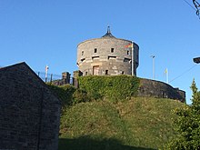
| Millmount Fort |  | website | 12nd century | Drogheda | County Louth | Europe | Ireland | 53.7115920000 | -6.3494840000 | Map | |||||||||||||
| Magdalene Tower, Drogheda |  | website | 13rd century | Drogheda | County Louth | Europe | Ireland | 53.7166671753 | -6.3499999046 | Map | |||||||||||||
| Saint Laurence Gate |  | Military | circa 1280 | website | Drogheda | County Louth | Europe | Ireland | 53.7000007629 | -6.3333334923 | Map | ||||||||||||
| St. Peter's Church of Ireland, Drogheda |  | Renaissance | Religious | 1772 | website | Drogheda | County Louth | Europe | Ireland | 53.7153000000 | -6.3546000000 | Map |