
| name | elevators | floors below ground | image | status | style | Area (m²) | type | use | date completed | Cost | Website | date Opened | date Start construction | Height (m) | city | administrative división | continent | Country | latitude (°) | longitude (°) | number of Floors | address | Map |
|---|---|---|---|---|---|---|---|---|---|---|---|---|---|---|---|---|---|---|---|---|---|---|---|
| Amsterdamse Poort, Haarlem |  | Protected/National interest | 1335 | website | Haarlem | North Holland | Europe | Netherlands | 52.3833351135 | 4.6500000954 | Amsterdamse of Spaarwouderpoort | Map | |||||||||||
| City Hall (Haarlem) | 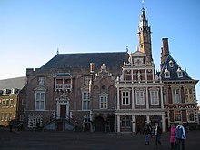 | Protected/National interest | Civil | Civil/Political | 17th century | website | Haarlem | North Holland | Europe | Netherlands | 52.3666648865 | 4.6333332062 | Grote Markt 2 | Map | |||||||||
| Coen Cuserhof |  | Educational | 1908 | website | Haarlem | North Holland | Europe | Netherlands | 52.3739777800 | 4.6245611100 | Map | ||||||||||||
| Doopsgezinde Weeshuis, Haarlem |  | Educational | 1874 | website | Haarlem | North Holland | Europe | Netherlands | 52.3748388900 | 4.6343416700 | Kleine Houtweg 18 | Map | |||||||||||
| Droste-branderij |  | Protected/National interest | Residential | 1911 | website | Haarlem | North Holland | Europe | Netherlands | 52.3871870000 | 4.6504780000 | Harmenjansweg 129 (Chocoladefabriek) | Map |