
| name | elevators | floors below ground | image | status | style | Area (m²) | type | use | date completed | Cost | Website | date Opened | date Start construction | Height (m) | city | administrative división | continent | Country | latitude (°) | longitude (°) | number of Floors | address | Map |
|---|---|---|---|---|---|---|---|---|---|---|---|---|---|---|---|---|---|---|---|---|---|---|---|
| Collegiate and Parochial Church of St Peter, Ruthin | 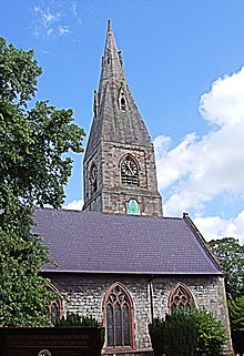 | Completed | 1310 | website | Ruthin | Wales | Europe | United Kingdom | 53.1154000000 | -3.3108000000 | Map | ||||||||||||
| Nantclwyd y Dre |  | 15th century | website | 1425 | Ruthin | Wales | Europe | United Kingdom | 53.0999984741 | -3.2999999523 | Map | ||||||||||||
| Ruthin Gaol |  | 1654 | website | 1654 | Ruthin | Wales | Europe | United Kingdom | 53.0999984741 | -3.2999999523 | Map | ||||||||||||
| The Old Rectory, Llanbedr |  | Residential | website | Ruthin | Wales | Europe | United Kingdom | 53.1166648865 | -3.2833333015 | Map | |||||||||||||
| 2 & 2A Well Street, Ruthin | Completed | 19th century | website | Ruthin | Wales | Europe | United Kingdom | 53.0999984741 | -3.2999999523 | 2 & 2A Record Street, Ruthin, Grade II listed building in Denbighshire. | Map |