| name | image | style | date demolished | type | use | administrative division | continent | date completed | date Start construction | Website | Height (m) | city | Country | latitude (°) | longitude (°) | Original_owner/Owner/Protection | Map |
|---|---|---|---|---|---|---|---|---|---|---|---|---|---|---|---|---|---|
| Blasenburg |  | Fortified Castle | Utrecht | Europe | website | Houten | Netherlands | 52.0016860000 | 5.1327390000 | Map | |||||||
| Blommesteyn | Unspecified | Utrecht | Europe | website | Houten | Netherlands | 51.9678970000 | 5.1931250000 | Map | ||||||||
| Grijpestein | Fortified Castle | Utrecht | Europe | website | Houten | Netherlands | 51.9851140000 | 5.1549780000 | Map | ||||||||
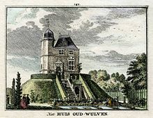
| Kasteel Oud-Wulven |  | Motte and Bailey | Utrecht | Europe | website | Houten | Netherlands | 52.0499992371 | 5.1500000954 | Map | |||||||
| Kasteel Schalkwijk |  | Fortified Castle | Utrecht | Europe | website | Houten | Netherlands | 51.9881580000 | 5.1905080000 | Map |