
| name | office head of government | Mayor | image | Area (m²) | date founded | Elevation (m) | Country | administrative division | continent | latitude (°) | waterbody | longitude (°) | Website | population (people) | Demonym | Map |
|---|---|---|---|---|---|---|---|---|---|---|---|---|---|---|---|---|
| Port Blair | 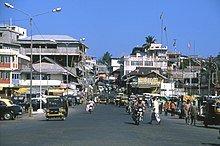 | 17 | India | Andaman and Nicobar Islands | Asia | 11.6683330536 | 92.7377777100 | website | 108,058 | Map | ||||||
| Anowa | India | Andaman and Nicobar Islands | Asia | 7.9604758000 | 93.5559665000 | website | Map | |||||||||
| Arainj-laka-punga | India | Andaman and Nicobar Islands | Asia | 12.5992461000 | 92.7207591000 | website | Map | |||||||||
| Bajajag | India | Andaman and Nicobar Islands | Asia | 11.7186705000 | 92.6673318000 | website | Map | |||||||||
| Bamboo Flat (Bamboo Flat) | India | Andaman and Nicobar Islands | Asia | 11.7081700000 | 92.7211179000 | website | 7,410 | Map |