
| name | image | status | type | Area (m²) | date Commissioned | date Opened | date Start construction | Website | Height (m) | Country | continent | Maximum discharge (m³/day) | lake | Installed capacity (w) | latitude (°) | Length (m) | longitude (°) | Turbines | volume (m³) | administrative división | city | Map |
|---|---|---|---|---|---|---|---|---|---|---|---|---|---|---|---|---|---|---|---|---|---|---|
| Brouwersdam |  | 1971 | website | Netherlands | Europe | 51.7666664124 | 3.8499999046 | South Holland | Ouddorp | Map | ||||||||||||
| maf Haringvlietdam dam | 15/11/1970 | 15/11/1971 | website | Netherlands | Europe | 51.8333320618 | 5,000 | 4.0500001907 | South Holland | Hellevoetsluis | Map | |||||||||||
| Schielands Hoge Zeedijk |  | 12nd century | website | Netherlands | Europe | 52.0200000000 | 4.6700000000 | South Holland | Zuidplas | Map | ||||||||||||
| Sturmflutwehr Holländische IJssel | 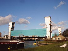 | 06/05/1958 | website | Netherlands | Europe | 51.9166679382 | 4.5666666031 | South Holland | Capelle aan den IJssel | Map | ||||||||||||
| maf Brouwersdam dam | 1971 | website | Netherlands | Europe | 51.7666664124 | 6,000 | 3.8666665554 | South Holland | Ouddorp | Map |