| material | name | light characteristic | heritage designation | image | tower shape | date Automated | date completed | date Opened | date Start construction | waterbody | Focal height (m) | Height (m) | date retired | Country | continent | latitude (°) | longitude (°) | Range (m) | Governing_body | administrative división | city | Map |
|---|---|---|---|---|---|---|---|---|---|---|---|---|---|---|---|---|---|---|---|---|---|---|
| Agö fyr | Fl WRG 5s | 1970 | Mar de botnia | 31 | 15 | Sweden | Europe | 61.5333328247 | 17.4500007629 | 14,484 | Gävleborg County | Hudiksvall Municipality | Map | |||||||||
| Djursten | LFl WRG 9s |  | 1839 | 1839 | Mar de botnia | 20 | Sweden | Europe | 60.3666648865 | 18.3999996185 | 17,703 | Uppsala County | Östhammar Municipality | Map | ||||||||
| Norra Långrogrundet | Fl(2) WRG 6s | Mar de botnia | 18 | 22 | Sweden | Europe | 63.3166656494 | -19.6666660309 | 12,875 | Västerbotten County | Nordmaling Municipality | Map | ||||||||||
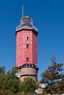
| Russarö |  | Mar de botnia | Finland | Europe | 59.7666664124 | -22.9333324432 | Uusimaa | Hanko | Map | |||||||||||||
| Skagsudde | Fl(4) W 12s |  | 1957 | 1957 | 1957 | 1957 | Mar de botnia | 39 | 26 | Sweden | Europe | 63.1833343506 | 19.0000000000 | 22,531 | Västernorrland County | Örnsköldsvik Municipality | Map |