| name | image | type | Annual cargo tonnage (kg) | date completed | date Opened | city | administrative división | continent | Website | Country | waterbody | latitude (°) | longitude (°) | Map |
|---|---|---|---|---|---|---|---|---|---|---|---|---|---|---|
| Port of Mina Al Fahal | Cargo | Muscat | Muscat Governorate | Asia | website | Oman | 23.6333332062 | 58.5000000000 | Map | |||||
| Port of Salalah | Unspecified | 11/1998 | Salalah | Dhofar Governorate | Asia | website | Oman | 16.9333324432 | 54.0000000000 | Map | ||||
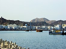
| Port Sultan Qaboos |  | Unspecified | 1974 | Muscat | Muscat Governorate | Asia | website | Oman | 23.6166667938 | 58.5666656494 | Map | |||
| SOHAR Port and Freezone | Unspecified | 2002 | Sohar | Al Batinah North Governorate | Asia | website | Oman | 24.5000000000 | 56.5999984741 | Map |