
| river | name | image | Average flow (m³/s) | type | Height (m) | elevation (m) | continent | latitude (°) | Country | location | longitude (°) | number of drops | Width (m) | administrative división | Map |
|---|---|---|---|---|---|---|---|---|---|---|---|---|---|---|---|
| Blaeberry River | Blaeberry Falls | Plunge/Punchbowl | Americas | 51.5166664124 | Canada | -116.9499969482 | 1 | British Columbia | Map | ||||||
| Lillooet River | Keyhole Falls |  | Plunge/Punchbowl | 35 | Americas | 50.6666679382 | Canada | -123.4666671753 | 1 | British Columbia | Map | ||||
| Wannon River | Wannon Falls |  | Plunge/Punchbowl | 30 | Oceania | -37.6666679382 | Australia | 141.8333282471 | 1 | Victoria | Map | ||||
| Eagle Creek (Multnomah County, Oregon) | Metlako Falls | 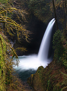 | Plunge/Punchbowl | Americas | 45.6253000000 | United States | -121.8968000000 | 1 | Oregon | Map | |||||
| Eagle Creek (Multnomah County, Oregon) | Punch Bowl Falls | 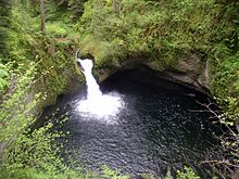 | Plunge/Punchbowl | Americas | 45.6166648865 | United States | -121.8833312988 | 3 | Oregon | Map |